
Science & Tech
Aboriginal hydropower
Navigating the the collaborative future between First Nations and the Canadian hydro industry
- 1135 words
- 5 minutes
This article is over 5 years old and may contain outdated information.
Science & Tech
The Canadian Hydropower Interactive Map helps Canadians understand the invisible but important role hydropower plays in their lives

Pause for a moment and consider the electricity that is powering the device you’re currently using. Where does it come from? If you’re reading this in Canada, chances are the laptop, phone or tablet you’re using is powered by water.
Many Canadians don’t know that hydroelectricity provides more than 60 per cent of Canada’s electricity needs. In fact, Canada has the third largest installed hydro capacity in the world, behind China and Brazil. But even though Canada has the existing infrastructure to produce about 78,000 megawatts, it has room to more than double its hydropower generation. That’s good news in a world where clean and renewable sources of energy are crucial in the fight against climate change.
The Canadian Hydropower Association and Canadian Geographic created the Canadian Hydropower Interactive Map to help Canadians understand the invisible but important role hydropower plays in their lives. The map allows anyone to explore the location of almost every Canadian hydro dam and generating station, what utility runs it, their size and the transmission network that connects the dams to cities and homes.
Click on the map below to find out if your life is powered by one of Canada’s greatest resources.
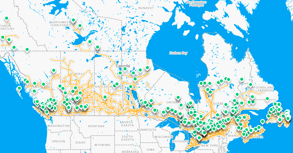
The Canadian Hydropower Interactive Map, created by The Canadian Hydropower Association and Canadian Geographic.
Science & Tech
Navigating the the collaborative future between First Nations and the Canadian hydro industry
Environment
Only a third of the world’s rivers longer than 1,000 kilometres remain free-flowing. In North America, 70 per cent of those are in Canada. Meet some of the people who want to keep it that way
Science & Tech
Contest submissions revealed unexpected and unique angles on hydro power

Mapping
Explore the major communication, transportation and energy lines that connect the world