Travel
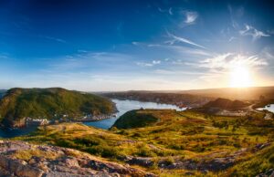
Exploring Newfoundland with Adventure Canada
Immerse yourself in Viking archaeology and Basque whaling history while taking in Newfoundland’s scenic coastline and incredible geology
- 1201 words
- 5 minutes
This article is over 5 years old and may contain outdated information.
Mapping
How a divisive political battle put Newfoundland on the map


Here’s a stumper. What’s missing from this geological map of Eastern Canada?
If you’re particularly sharp-eyed, you may have spotted that Nunavut doesn’t exist and that Iqaluit, the territory’s capital, is still labelled as Frobisher Bay. Or that in northwestern Ontario, Thunder Bay has yet to emerge from the amalgamation of Port Arthur and Fort William. So far, so very 1945 — the year the map was created.
But think bigger. Think Confederation. Then think colour — or the lack thereof. Now look east, where a finely delineated but decidedly pale Newfoundland and something that was then called “Coast of Labrador” sit, both apparently bereft of rocks. They aren’t, of course, but when this map was made, they were treated as such because Newfoundland still wasn’t officially part of Canada.
It would take another four years, nearly 17 months of internal deliberation and two referendums before Newfoundland joined Confederation, which it did on March 31, 1949, ending its 42-year run as a dominion of the United Kingdom wholly separate from that of Canada.
Joey Smallwood, who would go on to serve as the new province’s premier for nearly 23 years, led the campaign to join Canada, convinced that the union would help solve the economic woes that had plagued Newfoundland since just before the First World War and had been exacerbated by the Great Depression. But despite his oratorical skill and the strong base of support that he had in Newfoundland’s poor outport communities, Smallwood didn’t always have an easy time of it.
To start, the anti-Confederates labelled Smallwood a Judas and a traitor. What’s more, as Richard Gwyn notes in his book Smallwood: An Unlikely Revolutionary, such was the intensity of the vitriol levelled at Smallwood during the campaign that “To protect him, the Confederates hired two bodyguards, a former paratrooper and an ex-wrestler, who walked beside him even on the shortest journey across the street,” and “Smallwood himself carried a revolver, without a permit.”
But by the time the ballots in the second referendum were tallied on July 22, 1948, Smallwood’s side had won by a knife edge, with 52.3 per cent of the vote. In St. John’s and environs — where anti-Confederate support was the strongest — black flags flew and black armbands and ties were donned, but a sense of resigned pragmatism largely prevailed. No longer would Newfoundland “persist in isolation?… left far behind in the march of time,” as Smallwood had described it in 1946. Instead, it would be part of something much bigger.
*with files from Emily Macdonald, archivist, Library and Archives Canada
Travel
Immerse yourself in Viking archaeology and Basque whaling history while taking in Newfoundland’s scenic coastline and incredible geology

History
La Colombie-Britannique s’est jointe à la Confédération il y a 150 ans. Mais cela a failli ne pas se produire.

History
British Columbia joined Confederation 150 years ago. But it almost didn’t happen.
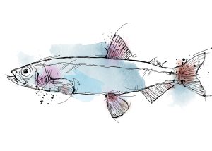
Wildlife
Writer Stephen Smith takes to Newfoundland’s shores in his quest to see the ‘capelin roll’ — the spawning spectacle of a tiny fish with a massive ecological, historical and cultural impact