History
2014 Victoria Strait Expedition
This year's search is about much more than underwater archaeology. The Victoria Strait Expedition will contribute to northern science and communities.
- 1205 words
- 5 minutes
This article is over 5 years old and may contain outdated information.
History

September 17, 2014, 23:00 Mountain Standard Time
Today was set for diving operations and there was no time to waste. With wind and sea conditions having improved overnight, and with so little time left, I shook our crew at first light to launch our ship’s fleet before7 a.m. to head out to the site.
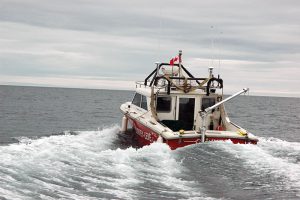
The crew from Parks Canada had spent the past several days preparing their dive equipment and finalizing dive and safety plans. They were ready and there would be no holding them back from exploring and filming the wreck for as long as their air would allow. We had our rigid hull inflatable made ready to deliver filled dive tanks throughout the day to keep their operation going strong.
Between dive operations, it fell to the Canadian Hydrographic Service to multi-beam the wreck from all angles and generate a high-resolution, three-dimensional image. This technology, on top of the Parks Canada’s side-scan sonar, adds an entirely new dimension to the analysis as the multi-beam can penetrate the vegetation to give a clearer look at the wreck structure itself. The multi-beam data will be used to support Parks Canada’s analyses, and will be overlain with the ship plans to identify features and assess structural integrity.
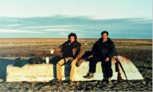
And if that wasn’t enough, Nunavut archeologist Douglas Stenton had much more of his own exploration work to do. Along with Canadian Hydrographic Service’s hydrographer Arthur Wickens and pilot Andrew Stirling, they lifted off for more land-based survey work and mapping of ancestral Inuit sites.
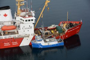
The Martin Bergmann also joined up with us this morning, and I met with captains McIsaac and Chidley and their senior crew while we topped up their water and fuel to discuss exit strategies to avoid the ice and enjoy fair winds en route to Cambridge Bay.
Dive operations, as well as hydrographic surveys, were finished late in the evening. And with the last zodiac sent out to ferry guests back to the Bergmann, the crew was tired. They’d need a good night sleep. We have less than a full day in the area to complete operations before we steam to Gjoa Haven. Logistics, ice and weather are shutting us down fast.
Are you passionate about Canadian geography?
You can support Canadian Geographic in 3 ways:
History
This year's search is about much more than underwater archaeology. The Victoria Strait Expedition will contribute to northern science and communities.
History
Arctic historian Ken McGoogan takes an in-depth, contemporary perspective on the legacy of Sir John Franklin, offering a new explanation of the famous Northern mystery
History
First official day of the 2014 search for Sir John Franklin’s lost ships
History
Introductory insights into the Canadian Coast Guard’s role in the search area