Environment
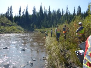
Healthy rivers: Communities use DNA tool to keep tabs on freshwater quality
Many of Canada’s 25 watersheds are under threat from pollution, habitat degradation, water overuse and invasive species
- 996 words
- 4 minutes
This article is over 5 years old and may contain outdated information.
Environment

Tuvalu, an island nation midway between Australia and Hawaii, acknowledges its greatest threat with a festival. Every February and March, when the tides are highest and most of the Polynesian island is submerged in water, the people sing, dance and make crafts to display their culture and history. They show the world what it will lose when climate change takes its first sovereign nation as a victim.
The Intergovernmental Panel on Climate Change estimates that sea levels will rise more than half a metre by 2100, fuelled, in part, by melting glaciers and warming ocean temperatures. Other scientific bodies warn that sea levels could rise by two metres. Tiny island nations such as Tuvalu stand little chance.
In British Columbia, the situation, although less dramatic, is an equally real threat. Tides considered extreme today are likely to become common by the end of the century. Coastal communities will have to adapt their infrastructure, including dikes, beaches and near-shore residences, to avoid or minimize damages from severe floods.
The first step to tackling the issue is to visualize it, says Tina Neale, a climate adaptation adviser with the province’s Ministry of Environment. She has helped coordinate the King Tide Initiative, now in its third year, which invites residents of coastal communities and professionals such as Coast Guard staff to snap photos of peak tides between November and January. The photos, which are shared on Flickr, are meant to help visualize a one-metre sea level rise.
The project is part of a broader campaign to prepare coastal communities for higher average tides coupled with the effects of more frequent storms. Neale’s department is also developing guidelines for sea-dike design and flood-plain mapping and a primer on the range of tactics, such as elevating beaches, that can be deployed to deal with rising seas.
The term “King Tides” is borrowed from Australia, where, in 2009, a regional government launched a similar project involving more than 250 volunteers. Coastal communities down under are also planning for more extreme tides, but under slightly different conditions. “It’s summer when their King Tides happen,” says Neale, “so they also have brighter and more colourful photos.”
The concept can apply to any coastal location. In British Columbia, the government is working with federal researchers to incorporate their data into weather forecasts, which may soon include information on tide levels for coastal areas. “This is intended to apply to all Canadians on the Atlantic and Pacific coasts,” says Neale, whose department is discussing the idea of starting a similar photo project with its East Coast counterparts.
Are you passionate about Canadian geography?
You can support Canadian Geographic in 3 ways:
Environment
Many of Canada’s 25 watersheds are under threat from pollution, habitat degradation, water overuse and invasive species

Environment
David Boyd, a Canadian environmental lawyer and UN Special Rapporteur on Human Rights and the Environment, reveals how recognizing the human right to a healthy environment can spur positive action for the planet
People & Culture
How a journey through the Great Lakes helped reshape my relationship with water after the loss of my father
Environment
How much do you know about Canada’s water — where it comes from and how it’s used?