New advances in interactive mapping are about to make things a whole lot easier for conservationists in the Northern Appalachian/Acadian eco-region.
The new map, which went online on Feb. 27, will integrate information from conservationists on both sides of the border with GIS information and make it easier to focus limited resources and collaborate on projects.
Gillian Woolmer, Assistant Director at the Wildlife Conservation Society, says the project is the result of a number of researchers and NGOs coming together to find a way to correlate their efforts to think bigger than the smaller areas they were focused on. A number of NGOs — sometimes consisting of no more than a couple of people — had gathered extensive GIS data but didn’t have the software or resources to put it on the map.
Woolmer began to help pull the information together with a free online tool called the Northern Appalachia/Acadian Online Atlas that became available in 2007. Now, updating the information to the interactive DataBasin platform will add significant user-defined potential that will make it more accessible to conservationists and government efforts.
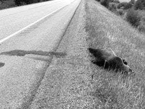
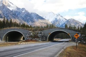
With DataBasin, conservationists will be able to create private and public collaborative spaces. The atlas contains over 30 maps and 80 data layers from conservation groups, communities and government agencies. Users will be able to add notes, edit information and share maps without GIS software to improve things like road crossings along important wildlife corridors and identify regions that can support carnivore populations of animals like lynx, American martens and potentially wolves if they return to the region. Users will also be able to customize their own maps based on the pool of shared information.
“It’s really a capacity building tool,” Woolmer says.
She says the benefits will be enormous to conservation efforts. Conservationists — who are often strapped for resources in their fight to protect wildlife — will be able to focus their efforts on areas in most critical need of protection. It will also help in defining wildlife corridors across national, provincial and state borders in an area spanning from New York to Nova Scotia and including parts of Quebec.
“There’s so few dollars out there to do conservation,” Woolmer says “Having this data at your fingertips really helps you get the most conservation bang for your buck.”
The potential for accumulating knowledge also means that conservationists won’t always have to start from scratch.
“You don’t need to reinvent the wheel,” Woolmer says, adding that the map will “put the latest conservation information into the hands of the people with their muddy boots on the ground.”