People & Culture
Kahkiihtwaam ee-pee-kiiweehtataahk: Bringing it back home again
The story of how a critically endangered Indigenous language can be saved
- 6310 words
- 26 minutes
This article is over 5 years old and may contain outdated information.
People & Culture

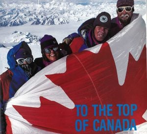
This photo has become nearly emblematic of The Royal Canadian Geographical Society, the non-profit educational organization that publishes Canadian Geographic magazine. Fun fact: it was taken on this day 20 years ago on the 150th anniversary of the Geological Survey of Canada, when a group of climbers took celebrations to a new level.
They had decided to climb Mount Logan in the Yukon, whose actual height had never been measured. Surveyors had previously used a theodolite, a type of telescope, to measure the mountain’s height. To get a more accurate measurement, the climbers lugged two GPS systems to the summit.
Sponsored by the RCGS, Michael Schmidt (who took the photo), Lisel Currie, Leo Nadeay, Charlie Roots, J-C. Lavergne, Roger Laurilla, Pat Morrow, Karl Nagy, Sue Gould, Alan Björn, Lloyd Freese, Kevin McLaughlin and Rick Staley flew to Quintina Sella Glacier to set up their base camp in May 1992. On May 12th, the team of GSC members, surveyors, mountain guides and park wardens began to climb.
They faced steep slopes, battled storms and bore the brunt of heavy loads that included climbing and scientific equipment. GPS was not as developed in 1992 as it is today, so they needed two sets of GPS units in case one failed. They also carried nearly half a ton of food for the entire climb.
On June 6, the first of four parties strapped on their skis and headed for Mount Logan’s summit with one of the GPS systems. Their original plan was to set up the system at the summit and descend and then have a second party return four hours later to check the GPS readings. The weather was so good that day that the first party stayed on the summit for four hours. That’s when one of the climbers pulled out the RCGS flag and posed for this photo.
It turns out Mt. Logan is 5,959 metres high, making its summit Canada’s highest peak.
Are you passionate about Canadian geography?
You can support Canadian Geographic in 3 ways:

People & Culture
The story of how a critically endangered Indigenous language can be saved

People & Culture
Part of our Colour the Trails series

Exploration
In 1992, a team backed by The Royal Canadian Geographical Society became the first to accurately measure the height of Mount Logan, Canada’s highest peak

Places
In Banff National Park, Alberta, as in protected areas across the country, managers find it difficult to balance the desire of people to experience wilderness with an imperative to conserve it