History
Parks Canada places commemorating the First World War
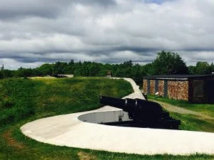
Sites across Canada honouring the war
- 1412 words
- 6 minutes
History
Canada’s part in the Battle of the Atlantic, shown here, is considered its most essential role in the war

As convoys of Allied ships set out from Nova Scotia and Newfoundland toward Europe through the Second World War, thousands of kilometres of ocean and German U-boats lay between them. Royal Canadian Navy warships escorted the Merchant Marine and other carriers of troops, munitions, fuel and military and civilian supplies during the Battle of the Atlantic. This multi-nation struggle over Atlantic shipping lanes began hours after Britain declared war on Germany on Sept. 3, 1939: a German U-boat sank the British ocean liner SS Athenia that day, and the war did not cease until 1945, more than 8,500 destroyed vessels and 70,000 Allied casualties later.
By June 1944, the Allies had largely gained control of their shipping lanes, and although German U-boats continued to sink ships until the war’s end, their efficacy was reduced. The Canadian Navy had evolved by then into the world’s top submarine-hunting navy, a status it retained for decades. Its last submarine “kill” of the Second World War came 75 years ago on March 21, 1945, when the frigate New Glasgow rammed a U-boat off the coast of Ireland. VE Day, for Victory in Europe, came on May 8, 1945, while the formal surrender of Japan and the end of the entire conflict came on Sept. 2.


Canada’s part in the Battle of the Atlantic, highlighted on the above map, is considered its most essential role in the war. Compared with the naval losses and kills racked up by Britain and Germany, Canada’s statistics sound modest: 43 Axis vessels destroyed, including more than 30 U-boats and a few Italian submarines; 77 Canadian Navy and Merchant Marine ships lost in turn; and more than 3,600 Canadians killed. But without Canadian escorts and expertise, many of the 25,343 ship transits from North America completed between 1939 and 1945 — accounting for nearly 165 million tonnes of vital supplies — would not have succeeded, and the war could have been lost.
The data used to create the map here was collected by Paul Heersink. Explore an interactive version of a map he created.
Canadian Geographic Commemorates 2020 is a series of articles, funded by the Government of Canada, celebrating milestone anniversaries of significance to the country’s history.
Are you passionate about Canadian geography?
You can support Canadian Geographic in 3 ways:
This story is from the July/August 2020 Issue
History
Sites across Canada honouring the war

Exploration
Caving: The ultimate underground sport

Travel
The trail started with a vision to link Canada coast to coast to coast. Now fully connected, it’s charting an ambitious course for the future.
Environment
How much do you know about Canada’s water — where it comes from and how it’s used?