Exploration
Return to the Peel
We came to retrace an ancestor’s 1905 map-making expedition of the Peel River watershed. We left with a new-found appreciation of what this ancient land means to the people who live there.
- 2676 words
- 11 minutes
This article is over 5 years old and may contain outdated information.
Exploration


In March 1905, The Royal Canadian Geographical Society founder Charles Camsell set out from Ottawa to do the first official mapping and exploration of the Peel River watershed in the Yukon and Northwest Territories for the Geological Survey of Canada.
“I was to go by canoe from Dawson, up Stewart River to its headwaters, and find, if possible, a pass across the mountains into the Wind River and to descend that stream to the Peel,” he wrote in his memoir, Son of the North. “Placer gold was meant to have been found on a tributary of the Wind called Hungry Creek and this was to be examined carefully.”
In the era before air travel, he and his crew of six would cover more than 4,100 kilometres on northern rivers, mostly by canoe, between the ice breakup in May that year and its return in October.
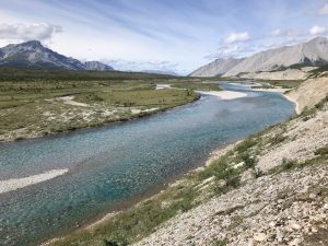
This summer, 113 years later, my cousin Terry Camsell, my son Graham and I are going to re-enact part of that epic journey, with the generous assistance of an expedition grant from the RCGS. We’ll also be making the most of advances in air travel since 1905, which will help cut our river travel down to some 500 kilometres. We’ll be paddling down the Wind and Peel Rivers to Fort McPherson, through what is one of the most beautiful and pristine wilderness areas left in North America.
Happily it is also a part of the journey Camsell described in his memoir this way, “Our chief troubles appeared to be over, and though we had about 400 miles to go to Fort MacPherson, it was downstream all the way.”
I am Charles’ great-grandson. Terry is his great-nephew.
Part of our aim is to reintroduce Camsell to Canadians. In his lifetime, he was one of Canada’s most celebrated explorers. Born in 1872, his father was English, chief factor for the Hudson’s Bay Company in the Mackenzie District, and his mother was Métis from the Red River settlement. One of 11 children, he was raised at Fort Simpson on the banks of the Mackenzie River. He would go on to take part in the Klondike Gold Rush and run mail routes along the Liard River. In his late 20s, after studying at Harvard, he joined the Geological Survey of Canada, going on to chart hundreds of thousands of kilometres of the Canadian north before becoming federal deputy minister of mines and commissioner of the North.
Terry’s roots in the Peel run similarly deep. A Hay River native, and an icebreaker captain, his grandfather, special constable Sam Carter, was a member of the ill-fated “Lost Patrol,” the Northwest Mounted Police expedition that starved to death in 1910 on a treacherous winter journey from Fort McPherson to Dawson. The place where Carter finally succumbed to hunger is a planned stop along our route on the Peel.
My own roots are in the south. I grew up in Ottawa, in the home Charles built. I share his birthday, February 8, and his wanderlust, having reported from more than 40 countries in my 23 years as a journalist. My son Graham is the youngest of our crew, and has strong Camsell DNA, having canoed Nunavut’s Hood River and, further south, the Coulange and the French among others.
Our interest in revisiting my great-grandfather’s journey through the Peel watershed was piqued last December, when the Supreme Court sided with First Nations and environmental activists fighting to protect the region from government plans for extensive mineral exploitation.
We wondered what that decision said about how Canada has changed during the past century, in deciding how land is used and who gets a voice in making those decisions. Going to the source seemed like the best way to find those answers.
On July 14, we will meet in Whitehorse, journey from there north to Mayo, where a float plane will take us to the headwaters of the Wind River, and then on a two-week paddle north to Fort McPherson. Hopefully, we’ll be joined by the voices of ghosts from a similar journey, long ago.
Are you passionate about Canadian geography?
You can support Canadian Geographic in 3 ways:
Exploration
We came to retrace an ancestor’s 1905 map-making expedition of the Peel River watershed. We left with a new-found appreciation of what this ancient land means to the people who live there.
Environment
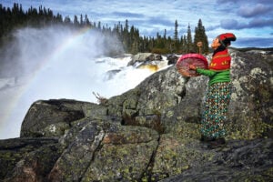
In February 2021, the world was introduced to Mutehekau Shipu — also known as the Magpie River — when the people of Ekuanitshit, Que. and the regional municipality made a joint declaration granting the river legal personhood and rights. The declaration carries broad implications for the fight to protect nature across Canada and around the world.

Exploration
David McGuffin shares insights from his daily log during his summer 2018 expedition retracing a legendary trek on the Yukon’s Peel River
Environment
Mark Angelo, founder of BC Rivers Day and World Rivers Day, shares insights on his love of rivers, his forthcoming film and what can be done to protect the planet’s waterways