What words would you use to describe the Arctic? Perhaps: cold, ice, snow or barren. But, perception is not always reality.
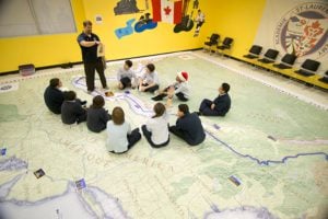
Canadian Geographic Education’s new giant floor map, Arctic Alive: Explore the natural history of Canada’s Arctic, created in partnership with the Canadian Museum of Nature, challenges those perceptions. The map and ten associated learning activities focus on the diversity of the Arctic, explored through specimens from the museum’s four main disciplines: zoology, botany, paleobiology and mineralogy.
But, bringing the Arctic to life on a floor map, while maintaining cartographic integrity posed a few unique challenges.
“The issue with this map was how to define the Arctic,” says Chris Brackley, cartographer for Canadian Geographic. “It was important to include places like northern Quebec and southern James Bay to allow students to consider the full range of what might be part of the region. The result was the somewhat unfamiliar view where many of our most populous regions are cut off.”
In addition to creating a different map extent than students are accustomed, careful attention was paid to the colours of the more than 20 different terrestrial and aquatic ecozones shown on Arctic Alive, as well as a variety of land cover.
Snow and ice, an important characteristic of the Arctic and the anchor of many ecosystems in the region, were also given a special treatment to distinguish different types, while remaining as true to life as possible.
“There are three distinct types [of snow and ice shown on this map], permanent snow/ice on land, seasonal snow-cover on land, and sea ice, “ says Brackley. “Seasonal snow is shown in the familiar white. For permanent snow and ice on land, I chose to add a bluish colour, as glaciers do have a very distinct blue tint to them. For sea ice, I gave it a greenish colour, which helped to distinguish it [from the surrounding environment].”
“[The goal was to] show the North as a land of diversity and colour, rather than a land of uniform, bleak whites and greys.”
For the Canadian Museum of Nature, the giant floor map is one part of a broader project focused on the diversity of the North, which will lead to a permanent Arctic gallery in 2017 to celebrate Canada’s 150th anniversary. The museum’s latest exhibition, Arctic Voices (open until May 3, 2015), uses interactive experiences, photos and artifacts to show the region’s natural environment and how it is changing. The exhibition also includes a special display of plant specimens collected from Sir John Franklin’s 1819-1822 expedition.
For more information on the giant floor map, visit education.canadiangeographic.ca.


