Wildlife
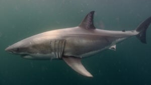
Jawsome: behind the scenes of Canada’s newest great white shark documentary
Korean-Canadian filmmaker Sonya Lee dives deep into the world of great white sharks for the latest documentary from CBC’s The Nature of Things
- 1781 words
- 8 minutes
This article is over 5 years old and may contain outdated information.
History


One hundred years ago, a devastating storm known as the White Hurricane devastated the Great Lakes region. Ships were overturned and hundreds of people died. Canadian Geographic spoke with Environment Canada climatologist David Phillips to learn about how the storm-warning system failed to protect mariners — and how weather forecasting changed as a result.
All weather services began as storm-warning systems. They were intended to tell mariners if something was coming.
In 1871, the national weather service was established in Canada. Two years later, the Great Nova Scotia Cyclone hit. Toronto knew that a hurricane was bearing down but couldn’t tell Nova Scotia because the telegraph wires were down. Nearly a thousand people died. It was incredibly embarrassing. The government put lots of money towards developing the national storm warning system after that.
By 1876, we issued 24-hour weather forecasts at 10 a.m. every morning except Sundays. The public forecast was sent to train stations, port officers, post offices and telegraph offices, where it was posted on the wall. It became very popular.
Then, in the 1880s, it began to appear in the newspapers. The editors didn’t like it at all, but people bought newspapers because of it. Something that amazes me is that, at the time, the public could also get a forecast by mail. The forecast could actually be posted in the morning and someone would get it by two in the afternoon.
In the early years of storm-warning systems in Canada, there were a series of towers and poles. The forecast office in Toronto would send out warnings to about 100 locations around the Great Lakes and the St. Lawrence. Port officers or harbour masters would use the pulleys to put up drums and baskets to communicate with the ship captains. A cone, or an inverted cone, would say something about the strength of the wind and the direction. And it worked! People were lulled into thinking that this system was saving all kinds of lives. And then this nasty storm came.
We often use that expression “the perfect storm.” From a meteorological point of view, the White Hurricane had a lot of elements that made it a tough storm. In November the waters of the Great Lakes are sometimes warmer then they are in June. The collision of cold air and Gulf of Mexico warm air create these weather bombs that develop over the Great Lakes. The strong winds at this time of year are called the Witches of November.
This particular storm had 100 km/h winds. But it wasn’t just the wind and the rain, it was also Paul Bunyan snowfalls and ice that caused communication lines to go out. When the telegraph cables were down, there was no forecast. You couldn’t even warn people about the storm. It was almost as if people heard about it by seeing ghost ships coming into the harbour with sailors tied to the mast and frozen to death.
The other interesting thing about this storm was that it lasted so long. In the Great Lakes area, storms can spring up quickly, but they hit and run. This one was a four-day event. People were weakened and exhausted by it. There were moments where people were seduced in thinking that it was over.
At the time, meteorologists would typically look at pressure values from across the continent and then plot these maps, draw the lines and see where the low-pressure systems were. But there were very few weather stations, so they couldn’t get the definition of the weather systems as readily as they’d want. They’d plot the map by hand and then try to compare it to other storms or events in the past. After the forecast was made, they’d send out this simple description of what would happen in the next 24 hours by telegraph. The forecasts were very simple then, for example: “Fair, with light winds from the northwest.” Then the shipmaster would look at it and hoist up the signal. But there was no control over whether or not they did their job. Mariners didn’t necessarily trust these things.
The delivery of information failed. People were vulnerable, and they were stuck out on the water without knowing what was coming or when it would be over. It was such chaos. The winds were switching from one direction to another, and the waves were actually coming from the opposite direction of the wind.
There were a lot of lessons learned from this storm. It raised concern that there were a lot of deficiencies in terms of not only the forecast office and the dissemination of the forecast, but in other aspects, even shipbuilding. There was a lot of concern that the ships plying the Great Lakes in these turbulent waters just weren’t the best that these engineers could produce.
After the storm, there were more college-trained people doing the forecasts. It couldn’t just be any high school graduate that you turned into a meteorologist. It was a wakeup call to make sure meteorologists and inspectors looked at whether the equipment was working. People also got thinking that maybe we should bury the telegraph lines.
The cooperation between Canada and the United States, which has always been good, was enhanced after this storm, because it affected international waters. There were both Canadian and American ships involved. This was a tragedy that both countries experienced.
The science of meteorology was galloping along at this time. There was recognition that it was a lot more complex than just storms moving west to east. And this particular storm was certainly ammunition to get better funding from the government.
Meteorology, communications, search and rescue, emergency preparedness, ship building, everyone took some fault for this. It’s almost as if you need these kinds of things to shake people up, to push people a little bit who are reluctant to make things more modern and push the limits.
Read more about the history of a national weather service in Canada
Are you passionate about Canadian geography?
You can support Canadian Geographic in 3 ways:
Wildlife
Korean-Canadian filmmaker Sonya Lee dives deep into the world of great white sharks for the latest documentary from CBC’s The Nature of Things

Wildlife
Dr. Chris Harvey-Clark shares his experience coming face-to-face with one of the ocean’s top predators while scuba diving near Halifax, N.S.

Wildlife
Encountering the carcass of one of the ocean’s top predators and how studying its remains can help researchers save the living

Environment
Experts predict a busier than normal hurricane season for 2016