Exploration
Surviving the Race to Alaska
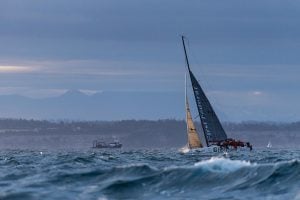
This motor-free ocean race — with vessels ranging from paddleboards to pedal-assist sailboats — is less about how fast you can go and more about whether you get there at all
- 3522 words
- 15 minutes
History


When Dutch cartographer and atlas publisher Jan Jansson drew this Arctic map in 1637, the top of the world had only started to come into focus for those trying to chart it. It was still the stuff of legend — a frigid and frozen whiteout roamed by Arctic peoples (who were often taken captive by early European explorers), strange beasts and a network of waterways that devoured ships.
While European Arctic exploration was picking up steam by the 17th century when Jansson drew this map, it was still very much in its infancy. Vikings were likely the first outsiders to set foot on Baffin Island in what’s now the Canadian Arctic, leaving traces in the form of bronze and glass from 1000 CE. Cartographic voyages to Greenland and northern Norway started in the late 1400s, and before the turn of the century, Venetian John Cabot led the first expedition in search of the famed Northwest Passage that would lure countless others. Cabot, however, ultimately landed in what is today Atlantic
Canada. Some 60 years later, England’s Sir Hugh Willoughby led three vessels in search of a northeast trade route from Europe to the Far East, sailing north from England along the west coast of Norway, and ending up at the entrance to the Barents Sea in Russia.
In 1575, English explorer Martin Frobisher began his first of three quests for the Northwest Passage through Meta incognita, Latin for “the unknown limit” and the name given to Baffin Island by Queen Elizabeth I. He reached Baffin Island and Hudson Strait. A decade later, England’s John Davis followed suit, but landed in northwestern Greenland, while Dutch explorer Willem Barentsz reached Spitsbergen, Norway, the farthest north of any expedition to that date, and one that later sparked the English whaling trade. Just before the turn of the century, in 1595, Flemish cartographer Gerardus Mercator gathered this new information in his magnum opus: Septentrionalium Terrarum, meaning “Of the Northern Lands,” the first full circumpolar map of the Arctic.
It was Mercator’s groundbreaking map that spurred his contemporaries, including Jansson, to create their own versions. Nova et accurata Poli Arctici, or “A new and accurate Arctic pole,” depicts Arctic Europe from the northern reaches of Russia and Norway, including an incomplete Spitsbergen, east to Iceland and Greenland, which is shown as being attached to the Canadian Arctic and without a northern coast. On this side of the world, Hudson Bay and Baffin Bay (which English explorer William Baffin surveyed in 1616) are charted on this map, as is part of Canada’s East Coast, including Newfoundland (Terra Nova) and Labrador.
In all, Jansson’s map served as a new prototype for polar maps, adding to the growing body of knowledge — and centuries-long fascination — of what was then “the unknown limit.”
Are you passionate about Canadian geography?
You can support Canadian Geographic in 3 ways:
Exploration
This motor-free ocean race — with vessels ranging from paddleboards to pedal-assist sailboats — is less about how fast you can go and more about whether you get there at all

Exploration
The team's thoughts on the 2020 Eco-Challenge through Fiji

People & Culture
Inside the 500-kilometre dogsled race across the High Arctic with the qimuksiqtiit who are sharing their knowledge with the next generation

People & Culture
Ottawa-area marathoner Steven Jackson is one of only 39 people to ever finish the 6633 Arctic Ultra