Results 29

cartography

The New York Times COVID-19 map

Mapping

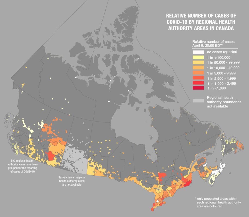
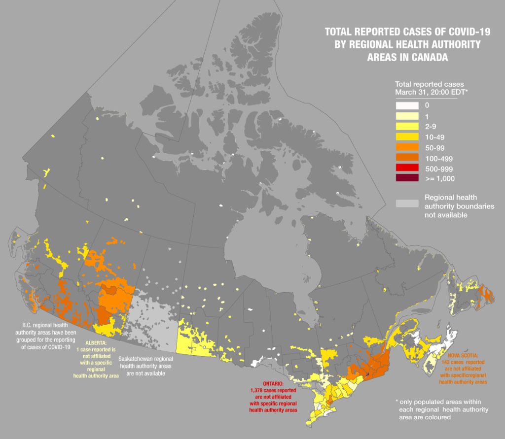
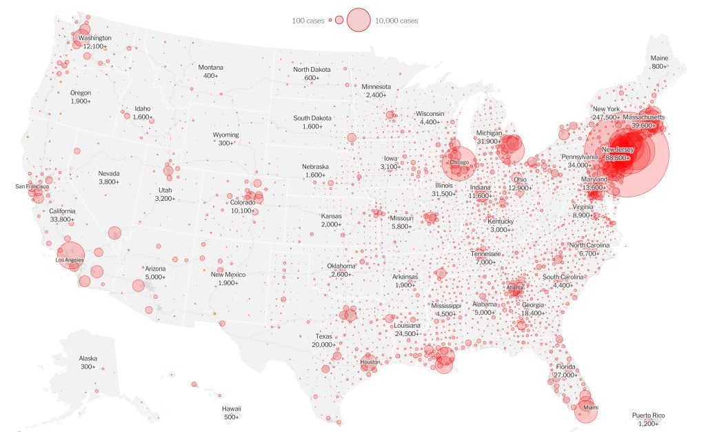
Mapping COVID-19: How maps make us feel

Canadian Geographic cartographer Chris Brackley continues his exploration of how the world is charting the COVID-19 pandemic, this time looking at how artistic choices inform our reactions to different maps

  • 1145 words
  • 5 minutes

Mapping

Mapping COVID-19 cases in Canada per capita

Canadian Geographic cartographer Chris Brackley continues his exploration of charting the coronavirus pandemic 

  • 743 words
  • 3 minutes
number of reported Canadian cases of COVID-19 by regional health authority

Mapping

What are maps really saying about COVID-19 in Canada?

Canadian Geographic’s cartographer explores how media, scientists and citizens are charting the coronavirus pandemic

  • 1180 words
  • 5 minutes
Best Canadian Geographic maps 2019

Mapping

Canadian Geographic’s best maps of 2019

Cartographic highlights from Canadian Geographic’s 2019 issues

  • 920 words
  • 4 minutes
Assassin's Creed Odyssey landscape

Mapping

Inside the intricate world of video game cartography

Maps have long played a critical role in video games, whether as the main user interface, a reference guide, or both. As games become more sophisticated, so too does the cartography that underpins them. 

  • 2569 words
  • 11 minutes

map

Advertisement

Articles

Mark Jeffery holds one of his goodwoodglobes prototypes at his home in Rossland, B.C.

Mapping

Meet the B.C. software developer who wants to bring back the globe

Inside the campaign to make the Earth spherical again

  • 730 words
  • 3 minutes

Mapping

Bulk Search Results

Science & Tech

Canada’s Arctic weather outposts

How the Joint Arctic Weather Stations program did more than just fill in a blank on the nation’s weather map

  • 435 words
  • 2 minutes
Child jumping into Skaha Lake, British Columbia

Mapping

Map shows where to find your perfect weather, all year long

Whether you like it hot, cold, or just right, the Perpetual Temperature map can help you plan your travels accordingly

  • 350 words
  • 2 minutes
A map showing Greenland's actual size compared to its Mercator projection portrayal

Mapping

Explore the real size of Earth’s land masses with this interactive map

The True Size map lets users compare countries by their actual size in square kilometres 

  • 287 words
  • 2 minutes
Freshwater map of Canada by Chris Brackley of Canadian Geographic

Environment

Map: Visualizing Canada’s fresh water

Canada is home to one-fifth of the world's fresh water. Here's what that looks like

  • 259 words
  • 2 minutes
A terrain model of a portion of Northeast Greenland National Park

Mapping

Satellites produce new ultra-precise topographic map of Earth

German satellites TanDEM-X and TerraSAR-X spent five years orbiting Earth in close formation to create 3D global map of unprecedented accuracy 

  • 247 words
  • 1 minutes