History
2014 Victoria Strait Expedition
This year's search is about much more than underwater archaeology. The Victoria Strait Expedition will contribute to northern science and communities.
- 1205 words
- 5 minutes
This article is over 5 years old and may contain outdated information.
History
September 12, just eight days away, is the 168th anniversary of the moment when Sir John Franklin’s HMS Erebus and Terror became locked in sea ice in Victoria Strait. The ice held the ships tight for two Arctic winters — with no relief between. It’s no stretch to imagine the despair that must have bred among the crew when the ice didn’t release its grip through the summer of 1847.
We know that much, and also that Franklin and two-dozen of his sailors had died by 1848, thanks to a note in a rock cairn discovered in 1859 at Victory Point, on nearby King William Island. The next chapters in the story have only been hinted at by a trail of artifacts and human bones scattered down coasts to the south and east.
Franklin, doubtless, would have thought he’d eventually escape that bit of Arctic Ocean between Victoria Strait and Larsen Sound. We had hoped we could stay longer.
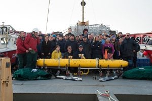
The ice-strengthened One Ocean Expedition Voyager, the only ship of the 2014 Victoria Strait Expedition to thrust into the main search area by September 3, zigzagged and bumped its way north through sea ice between the Royal Geographical Society Islands and the target waters northwest of King William Island. As wide pans of ice cracked and slid along the starboard and port sides, the prospect of enough open water to drop the unmanned sonar scanner Arctic Explorer (the autonomous underwater vehicle) began to ebb.
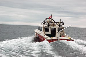
Voyager sent out the Grey Lady, its agile, 7-metre rigid-hull inflatable boat, to reconnoiter and take depth soundings in the northern part of the strait, much of which is uncharted, but further operations were rebuffed by the bands of ice still drifting over the point of the Erebus and Terror’s desertion and potential sinking.
“It’s profoundly moving to be at the place where Franklin’s crews abandoned the ships and began what turned into their death march,” says John Geiger, CEO of The Royal Canadian Geographical Society and its Head of Expedition. “To be back in the very spot where that happened, and to be here in the ice, makes for a moment of deep reflection.”
But the ice at the root of the Franklin disaster can still halt Arctic explorers in their tracks. “We’re here with a lot of capability, but we were under the illusion, as it turns out, that there would be no ice at this time of year,” adds Geiger. “What we’ve found, of course, is that there is ice, and enough of it to prevent us from deploying the AUV. It’s extremely frustrating to be in the key search zone, unable to search.”
As delicately as it was piloted north, past Victory Point and to the point of abandonment, the 117-metre Voyager is now picking its way through fog and lighter ice cover back to the north side of the Royal Geographical Society Islands. It’s still within the bounds of the expedition’s northern search area, and where on its first mission the AUV collected seven square kilometres of high-definition sonar images, already being scrutinized on board by analysts from the St. John’s-based company (Kraken Sonar Systems) that built the sophisticated side scanners mounted to each side of the torpedo-esque robot.
“We’re going back to widen our search for Erebus and Terror and any debris,” says David Shea, engineering manager for Kraken, “but now we’re at an advantage because we know exactly what to expect of the seabed. We had no idea what it looked like — in terms of how much silt, rocks and other deposits there would be — and now we know that it’s mainly hard packed clay, with the odd geological formation and a number of deep iceberg scours. If anything is lying down there, it will be right on top of the clay, with very little sediment to disguise it.”
“The plan now is to try to get as much data as possible from that area north of the Royal Geographical Society Islands,” says Marc-André Bernier, chief of Parks Canada’s Underwater Archaeological Service. “There are options on all three sides of the islands, and we should be able to deploy later today. We have to ‘go with the floes.’ Sometimes there’s hope, and sometimes the ice just closes.”
As Robbie Burns wrote, “The best-laid schemes o’ mice an’ men … [go often awry],” and that seems doubly true of plans laid for the North. The great thaw and breakup of sea ice in the straits and sounds of Canada’s central Arctic came later this year than it has in the last four, and every day Franklin searchers reset their strategies to accommodate the ice’s movements — while maximizing their scanning potential. By the September 12 anniversary of Franklin’s besetment, stiffer winds may have blown through Victoria Strait and helped sweep the ice away from the point of abandonment, or the stuff could well have started to spread and set for another winter.
“For now,” says Bernier, “we’re working our way toward open water instead of waiting for it.”
Are you passionate about Canadian geography?
You can support Canadian Geographic in 3 ways:
History
This year's search is about much more than underwater archaeology. The Victoria Strait Expedition will contribute to northern science and communities.
People & Culture
Award recipients honoured in the first virtual Annual General Meeting and Fellows Show.
Environment
Ten years after the release of her seminal book Sea Sick, Alanna Mitchell again plumbs the depths of the latest research on the health of the world’s oceans — and comes up gasping
History
Why this summer’s search for the lost ships of the Franklin Expedition will be the biggest and most advanced ever