People & Culture
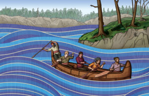
Rivers of resistance: A history of the Métis Nation of Ontario
“We were tired of hiding behind trees.” The ebb and flow of Métis history as it has unfolded on Ontario’s shores
- 4405 words
- 18 minutes
This article is over 5 years old and may contain outdated information.
Mapping


To monitor the state of thousands of provincial bridges in Ontario, the government gives each a score.
Ontario’s 2,800 bridges all have a Bridge Condition Index (BCI) ranking, based on an inspection of their physical condition. Those scores were released earlier this year, when the provincial government released updated BCI data online as part of its Open Data initiative. (The online version only goes until 2013. The latest version, going until the end of 2014, was provided to Canadian Geographic.)
A score between 70 and 100 is considered good (maintenance isn’t usually required within five years), between 60 and 70 is fair (maintenance usually scheduled within five years to get the most out of bridge spending) and less than 60 is considered poor (maintenance work is usually scheduled within a year).
Ministry of Transportation spokesman Ajay Woozageer said in an email that the index reflects the physical condition of a bridge, rather than its safety or structural load carrying capacity.
“MTO prioritizes and schedules the rehabilitation for these bridges according to the availability of funding as well as other factors such as other work in the vicinity of the bridge,” he said.
Explore the map to see what BCI score bridges were given at the time of their last inspection.
Sibley Creek Bridge in Thunder Bay has the lowest score in the province–a paltry 33.3.The bridge was given that score in the summer of 2014 and it has since been rehabilitated, Woozageer said. While construction finished early this year the bridge hasn’t been re-inspected, so a new score hasn’t been recorded.
Detailed inspections are completed every two years and maintenance inspections happen at least twice a year. The date of a bridge’s most recent inspection is indicated on the map. See a full-page version of the map here.
Are you passionate about Canadian geography?
You can support Canadian Geographic in 3 ways:
People & Culture
“We were tired of hiding behind trees.” The ebb and flow of Métis history as it has unfolded on Ontario’s shores

Wildlife
Algonquin wolves face an uncertain future primarily because they can be legally shot and trapped in many parts of Ontario

Wildlife
The turtles we keep as pets don’t belong in the wild

Science & Tech
Dr. Molly Shoichet discusses her new role and how she plans to restore the public’s trust in government science