People & Culture
The cod delusion
A moratorium on cod fishing that was supposed to last two years has now lasted 30. What will it take to rebuild cod stocks — and a way of life?
- 3119 words
- 13 minutes
This article is over 5 years old and may contain outdated information.
Mapping

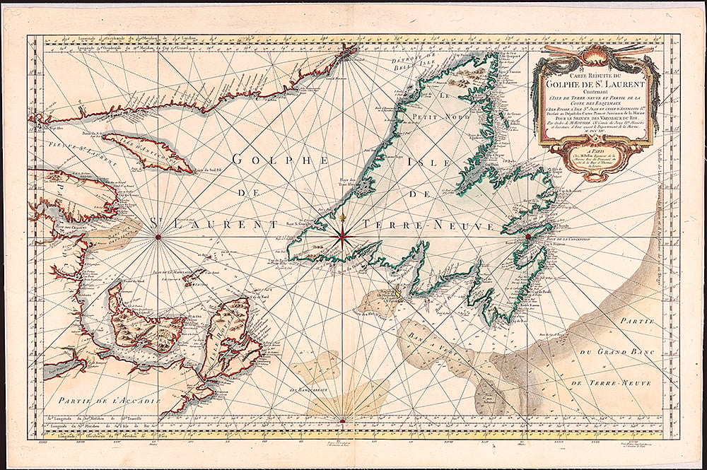
There’s a saying that goes “Everything is ____ .” The blank is often filled in with “politics,” “economics” or “art.” This hydrographic chart, which Jacques-Nicolas Bellin published in Paris in 1754, is a classic example of cartography’s ability to bring three such concepts together to tell a larger, complex story simply and beautifully.
The chart shows a small portion of the Grand Banks, the fishing grounds off the southeast coast of Newfoundland where cod once thrived. When the map was published, the fish had already been a key resource for Europeans for more than 200 years. Indeed, the fishery’s economic importance made it a serious political issue — so much so, in fact, that cod had a hand in shaping geopolitical boundaries in the region from the early 1700s to the early 1900s.

Following the Treaty of Utrecht in 1713, Britain gained control of Newfoundland, forcing the French to abandon the fishing colony of Plaisance (today’s Placentia, on the province’s southeast coast). France retained seasonal fishing rights on the French Shore, an area along Newfoundland’s north and west coast, until 1904. Cod is also the reason why France wanted to retain possession of the islands of Saint Pierre and Miquelon after the Treaty of Paris in 1763, territory it still holds.
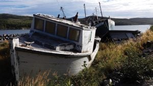
The bountiful catches would not last, however. By 1992, with cod stocks dangerously low, the federal government imposed a moratorium on the fishery. Tens of thousands were put out of work, and to this day the Atlantic cod is considered a species at risk.
With files from Isabelle Charron, early cartographic archivist, Library and Archives Canada
During the 18th century, explorers took the lion’s share of fame with journeys that took them around the world and into unfamiliar, often dangerous territory.
Their voyages, however, would have been much more difficult without the help of the era’s rather less lauded stars — cartographers. And if there was a rock star among mapmakers in the 1700s, it was Jacques-Nicolas Bellin.
Bellin created remarkably accurate maps and nautical charts of locations all over the world, including locations in Canada, the United States, Central and South America, Asia, Africa and the Middle East.
Born in Paris in 1703, Bellin had a career that spanned 50 years. At just 18, he was appointed chief cartographer to the French navy. Twenty years later he became the official hydrographer to the French king, a position of considerable prestige that helped cement his reputation as one of the leading cartographers of his time.
Bellin worked hard to perfect his maps and nautical charts, continuously gathering information from navigational journals, itinerary reports and astronomical observations. His maps, which eschewed the more decorative look of earlier cartography in favour of functionality and accuracy, did more than simply differentiate east from west or north from south; they reflected discoveries and ongoing geopolitical events in places such as North and South America.
— Siobhan McClelland
Are you passionate about Canadian geography?
You can support Canadian Geographic in 3 ways:
People & Culture
A moratorium on cod fishing that was supposed to last two years has now lasted 30. What will it take to rebuild cod stocks — and a way of life?
Environment
The animated short film called Last Fish, First Boat recounts the 1992 cod moratorium

Mapping
Maps have long played a critical role in video games, whether as the main user interface, a reference guide, or both. As games become more sophisticated, so too does the cartography that underpins them.
Mapping
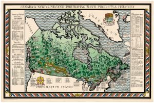
A bountiful cod industry is pictured on a 1920s map. Decades later, a moratorium would change everything.