This article is over 5 years old and may contain outdated information.

Mapping

Interactive map shows global air pollution in realtime

'World Air Map' shows us exactly what we're breathing in at any given moment in major cities around the world.
  • Jan 24, 2016
  • 241 words
  • 1 minutes
Expand Image
Advertisement

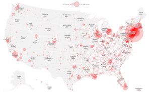
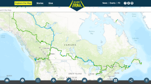
Air pollution is largely invisible, affects everyone’s health, and is mostly out of any single person’s control. But tech company Plume Labs wants to empower people to make smarter decisions with its World Air Map, which shows realtime air quality around the world.

The data comes from local monitoring stations in over 150 cities. While these results are already released publicly, the desktop-based World Air Map and companion smartphone app aim to put the information in context and make it more accessible.

The mobile application is especially useful for those in high-pollution spots or for people with chronic health conditions who are particularly sensitive to pollution. It delivers alerts about pollution levels in the user’s city, and can even predict the best time to plan outdoor exercise. For the fair-skinned among us (hi!), it also includes a UV index.

Canadian cities tracked include Toronto, Ottawa, Vancouver, Montreal, and Hamilton.

Worldwide, the World Health Organization (WHO) estimates that 3.7 million people die prematurely every year from outdoor air pollution, with the vast majority of deaths (88 per cent) happening in developing countries.

According to WHO, the pollutants of major public health concern include particulate matter, carbon monoxide, ozone, nitrogen dioxide and sulfur dioxide.

Cars, industrial facilities and forest fires are all common sources of air pollution, which can increase the risk of respiratory and heart disease, especially among children and the elderly.

Advertisement

Are you passionate about Canadian geography?

You can support Canadian Geographic in 3 ways:

Related Content

The New York Times COVID-19 map

Mapping

Mapping COVID-19: How maps make us feel

Canadian Geographic cartographer Chris Brackley continues his exploration of how the world is charting the COVID-19 pandemic, this time looking at how artistic choices inform our reactions to different maps

  • 1145 words
  • 5 minutes
Assassin's Creed Odyssey landscape

Mapping

Inside the intricate world of video game cartography

Maps have long played a critical role in video games, whether as the main user interface, a reference guide, or both. As games become more sophisticated, so too does the cartography that underpins them. 

  • 2569 words
  • 11 minutes
The War of 1812 giant floor encourages students to interact with history

Kids

Giant floor maps put students on the map

Canadian Geographic Education’s series of giant floor maps gives students a colossal dose of cartography and is a powerful teaching tool

  • 1487 words
  • 6 minutes

Mapping

How the Great Trail interactive map is linking communities and changing exploration

As Canada's most famous trail celebrates its near completion, Esri Canada president Alex Miller discusses the ambitious trail map that is helping Canadians get outdoors

  • 1298 words
  • 6 minutes