Science & Tech
20 Canadian innovations you should know about
Celebrating Canadian Innovation Week 2023 by spotlighting the people and organizations designing a better future
- 3327 words
- 14 minutes
This article is over 5 years old and may contain outdated information.
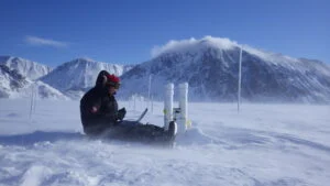
Mapping


It’s safe to say that Dennis Reinhartz probably knows as much about Herman Moll — the man who created what’s commonly referred to as the beaver map (pictured below) — as anyone in the world. Although Reinhartz, the author of The Cartographer and the Literati: Herman Moll and His Intellectual Circle, is now retired from his position as professor of history and Russian at the University of Texas at Arlington, his keen interest in Moll and the history of cartography hasn’t faded.
Who was Herman Moll?
There still seems to be some confusion about where exactly he was from, but I think he was German, probably from around Bremen. He came to England in 1678, when he would have been in his 20s, probably for his own economic benefit, but also probably to avoid the Scanian Wars, which were going on in the region at the time. By the time he got to London, he was a master engraver — a skill he may have picked up in northern Germany or in the Netherlands — and his expertise was pretty quickly recognized.
How did he distinguish himself after arriving in London?
By the late 1680s, he was working for some of the more important printers there, and by the late 1690s, he was breaking out on his own. His skill pretty much opened the way for him. He worked in metal-plate engraving, where you can achieve a very fine line and an exactness, both of which are reflected in the printed version. He was very precise, very distinct in his workmanship and in his lettering. In fact, it’s probably his lettering more than anything that discerns a Moll map. Others who copied his maps also just went right along and copied his lettering — and we’re talking about a number of fairly important British mapmakers in the first half of the 18th century. [Moll himself wasn’t innocent of the then common practice of copying maps. Indeed, the image of beavers and Niagara Falls on his beaver map was copied from Nicolas de Fer, who had published a chart with an identical scene on it in 1698. It gets worse; de Fer copied his illustration from images that had first been printed in not one but two books, one by Louis Hennepin in 1697, the other by Francois Du Creux in 1664. — Ed.]

What is Moll’s best known or most famous work?
Content wise, his work wasn’t all that exceptional, because, other than a few rare exceptions, he was working off the same pool of knowledge that everyone else had. He did have some ins with certain navigators, such as the Englishmen William Dampier and Woodes Rogers. Dampier gave him an edge on information coming out of what would become Australia, the area to the northeast of Australia and the Solomon Islands. These were very obscure parts of the world at the time, and if Moll has a claim to fame of being cutting-edge information-wise, that’s where it is. Meanwhile, the beaver map may be his most famous work, but I’d argue that probably his best designed map is his version of the West Indies.
How was his cartographic work political?
Look at his maps, and especially at the dedications and commentaries on them. The commentaries were one of the things that made his maps unique. They don’t just describe a place, but also contextualize an area, and the type of contextualization tends to be somewhat political. If you look at his maps, it’s pretty easy, I think, to point out that Moll was a Whig [A member of the English reforming and constitutional party that sought the supremacy of parliament and was a precursor to Britain’s Liberal Party — Ed.] For example, the people he dedicated his maps to were Whigs, but sometimes the dedication was there when those people were falling out of favour. In some of the events he’s commented upon on his maps, there’s definitely a Whig perspective. He was an advocate for the British Empire, and the beaver map is a booster map.
Moll was known to have some famous acquaintances. Who were they and how did he come to meet them?
He was involved in this intellectual circle of William Stukeley, who was your sort of classic 18th-century man — a doctor with a background in law who was an antiquarian and fascinated by the druids and their semi-mythological role in Britain’s history. Stukeley gathered around him historians, members of the Royal Society, those types of people, including Moll. But Moll also knew Daniel Defoe and Jonathan Swift. In fact, Moll was commissioned to create the maps for Swift’s Gulliver’s Travels, in which he’s mentioned by name [Moll is mentioned once in Swift’s story, near its end, when Gulliver is discussing maps and charts, and refers to the cartographer as “…my worthy friend, Mr. Herman Moll….” — Ed.], and he also drew the original maps for Defoe’s Robinson Crusoe.
What would you ask Moll if he were alive today?
In my book, I was really interested in these wonderful intellectual circles that began in Britain in the second half of the 17th century and blossomed in the first half of the 18th century, one of which Moll was a member of. I’d like to know how the ideas of applied science that they discussed, which weren’t always correct, developed and were shared. I would really love to ask Moll about the discussions that went on between him and his peers in these situations, and about the extent of these circles that he moved in.
Are you passionate about Canadian geography?
You can support Canadian Geographic in 3 ways:
Science & Tech
Celebrating Canadian Innovation Week 2023 by spotlighting the people and organizations designing a better future
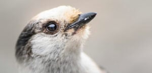
Wildlife
Canada jays thrive in the cold. The life’s work of one biologist gives us clues as to how they’ll fare in a hotter world.
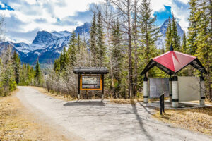
Travel
The trail started with a vision to link Canada coast to coast to coast. Now fully connected, it’s charting an ambitious course for the future.
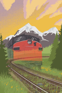
People & Culture
What does it mean for Canada if we continue to pull up train tracks?