
People & Culture
On thin ice: Who “owns” the Arctic?
As the climate heats up, so do talks over land ownership in the Arctic. What does Canadian Arctic Sovereignty look like as the ice melts?
- 4353 words
- 18 minutes
This article is over 5 years old and may contain outdated information.
Science & Tech


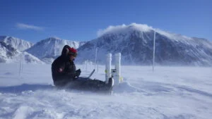
“In addition to possessing thorough technical knowledge of meteorological equipment, applicants must be comfortable with long periods of isolation and cold, and be prepared to live and work in close quarters with a small group of colleagues for a year or more at a time.”
OK, so this is an imaginary version of what was required of personnel at the five Joint Arctic Weather Stations (JAWS) active across the Canadian High Arctic from 1947 to 1972, but its take-heed tone about the physical and mental hardships of life in the North probably isn’t far off the mark. After all, staffing the stations was serious business for the Canadian and American officials who initiated the JAWS project.
They did so to redress an imbalance that for years had left the region covered by Canada’s Arctic islands appear as a large blank area on weather maps, as R.W. Rae noted in his story on the stations in a 1951 issue of Arctic, the journal of the Arctic Institute of North America. “The need for weather reports from this blind spot was recognized, but the difficulty and expense involved in the establishment and maintenance of communities in these inaccessible regions were prohibitive.”
But the Second World War and its aftermath made the Arctic relevant for world powers such as the United States, and soon after the war ended, the first station was established at Eureka on Ellesmere Island. By April 1950, four more stations — Resolute on Cornwallis Island, Isachsen on Ellef Ringnes Island, Mould Bay on Prince Patrick Island and Alert on Ellesmere Island — were operational.
Maps such as the one above, which depicts the Eureka station, part of the east coast of Axel Heiberg Island and part of the west coast of Ellesmere Island, show the region that each station’s staff gathered data for by making on-the-ground observations and by using weather balloons to measure temperature, barometric pressure, humidity and wind direction.
The information was used for more than creating a reliable Arctic forecast, though. “The data these stations gathered,” wrote historian Daniel Heidt in a 2015 Network in Canadian History & Environment story about the stations and the “met techs” who worked there, “were crucial to military planning, civilian meteorology, and transatlantic commercial aviation, as well as North America’s agriculture and forestry economies.”
No pressure on the met techs, then. It’s no wonder, as Rae noted, that great care was “exercised in screening applicants for these posts since one unsuitable individual can disrupt the harmony of the entire station.”
*with files from Erika Reinhardt, archivist, Library and Archives Canada
Are you passionate about Canadian geography?
You can support Canadian Geographic in 3 ways:
People & Culture
As the climate heats up, so do talks over land ownership in the Arctic. What does Canadian Arctic Sovereignty look like as the ice melts?

Kids
Canadian Geographic Education’s series of giant floor maps gives students a colossal dose of cartography and is a powerful teaching tool

Environment
The uncertainty and change that's currently disrupting the region dominated the annual meeting's agenda
Science & Tech
Celebrating Canadian Innovation Week 2023 by spotlighting the people and organizations designing a better future